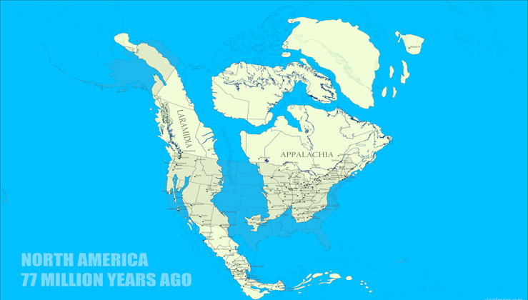
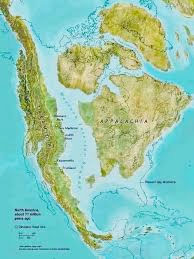
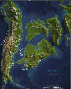
A vivid map shows what North America looked like 77 million years ago, when a vast inland sea split the continent and dinosaurs roamed the land.
During the Cretaceous Period—spanning roughly from 145 to 66 million years ago—the Earth was a dramatically different place. This final chapter of the Mesozoic Era was characterized by warm global temperatures, a total lack of polar ice, and extremely high sea levels. The result? Much of what we now call North America was underwater. In particular, a massive body of water known as the Western Interior Seaway split the North American continent in two. This shallow inland sea stretched from the Gulf of Mexico to the Arctic Ocean, submerging many regions that today are dry land—including large swaths of what are now U.S. states such as Colorado, Kansas, Nebraska, and New Mexico. Forests flourished from equator to pole, and the land was ruled by an astonishing variety of dinosaurs. The seas were teeming with creatures now long extinct: ammonites, rudists, and powerful marine reptiles.
The skies saw the rise of more modern-looking birds, and the ground witnessed the early diversification of mammals. Flowering plants, which first emerged in the Early Cretaceous, rapidly became dominant and started to resemble the flora we know today—magnolias, redwoods, roses, and willows all appeared toward the end of the period. By the Late Cretaceous (100.5 to 66 million years ago), the Earth’s tectonic plates were slowly shifting into the arrangement we now recognize. The Americas drifted westward, widening the Atlantic Ocean. India was still moving north, clinging to Madagascar, and Australia was joined to Antarctica. Northern and southern landmasses remained separated by the immense, curving Tethys Ocean. In this ancient world, Western North America was a hotspot of dinosaur activity.
Hadrosaurs, ceratopsians, ankylosaurs, tyrannosaurs, and dromaeosaurs thrived. Tyrannosaurs, in particular, ruled the top of the food chain. In the north, mammals like multituberculates, cimolodonts, and early eutherians were the dominant small land animals. But the world was changing. A subtle cooling trend began to creep in, shrinking tropical zones to more equatorial regions and introducing more pronounced seasons in the northern hemisphere. This era came to a dramatic close with the Cretaceous–Paleogene (K–Pg) extinction event, an ecological catastrophe that wiped out nearly three-quarters of Earth’s species, including all non-avian dinosaurs, flying pterosaurs, and massive sea reptiles. Today, the remnants of this long-gone world are still visible.
Fossils of marine life can be found in the Rocky Mountains—proof that areas like Colorado and New Mexico were once seafloor beneath the Western Interior Seaway. To bring this lost world to life, the team at VividMaps.com created a vivid and scientifically informed map of North America as it appeared 77 million years ago. The map shows which modern U.S. states were underwater and offers a compelling view of the continent’s prehistoric geography. In a fun twist, VividMaps also created a playful version of the 2020 U.S. presidential election map—reimagined as if continental drift had never occurred, and the land remained as it was in the Cretaceous. It’s a quirky but thought-provoking reminder of just how much the planet has changed—and how fleeting our current geography may be in the grand timeline of Earth’s history.